| Maritime Topics On Stamps :
Cook's Second Pacific Voyage!
|
|
|
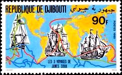
The first Pacific voyage of Captain James Cook took from 1768 to 1771. On the stamp to the
right the course is marked with a red line. The second voyage lasted from 1772 to 1775
(marked with a blue line) and is dealt with in detail on this page.
The third Pacific voyage started in 1776 and ended 1780, course marked by the green line.
|
|
|
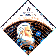
On the stamp to the left the astronomer, geographer and mathematician Claudius Ptolomaeus
(100 till 160 AD) is depicted. He was convinced that the earth was a huge globe and drew a
new chart of the world, on which the northern part of the globe was represented in detail.
The southern part was simply outlined with dotted lines and labeled 'terra incognita', "the
unknown country". Scientist at that times thought, that the well known northern continent
must have a counterpart to the south - on the other side of the world.
On this second voyage of Captain Cook the main goal was to find this mysterious continent.
Moreover Dutchmen and Frenchmen were feverishly searching this southern land as well.
|
|
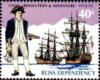
Cook again chose a coal vessel for this voyage: the 'Resolution', a three mast barque, 462
tons, length 112ft, beam 30ft, draft 13ft; see stamp above at the headline. Because of
the critical situations encountered on his first voyage with the 'Endeavour' he chose an
escort vessel to accompany him: the 'Adventure', 336 tons.
Again Cook had various scientists and an astronomer on board. And for the first time he had
access to an excellent instrument, a copy of Harrison's famous no. four marine chronometer.
This chronometer enabled him to exactly determine the longitude at sea.
|
|
|
| |
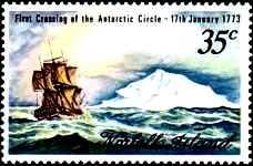
From Cape Town Cook directly sailed southward until he reached the pack-ice border.
In the misty and stormy weather it was extremely difficult to manouvre between the huge table
icebergs and many ice floes. On January 17th, 1773, they crossed the Antarctic Circle.
One day later they stand only 75 nautical miles off continent of Antarctica. But the ice forced them
back. To make matters worse the 'Resolution' lost contact with the 'Adventure' in a heavy gale.
|
|
|
During the three years of this voyage Cook tried three times to direct his ship to more southerly
latitudes. For the whole crew it was a continous fight against hurricanes, extreme coldness and
huge, mountain-like waves. The sails were frozen rigid, dangerous icicles rained from the rigg
onto the deck, all ropes were frozen. Fog and icebergs required highest concentration around the
clock. It became necessary to travel to New Zealand three times. There the crew was able to
recover and repair the ship. At New Zealand they met the 'Adventure' again, but later on they
lost them for a second time during a storm.
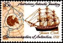
On the stamp to the right the courses of Cook are depicted and one can see, that he has circled
the whole Antarctic continent from west to east.
|
|
Two times Cook changed the course to sail to more northerly Pacific islands and archipelagos.
The first time he sailed in a great circle to the Easter Islands. There Cook visited the big
stone figures and was amazed by the natives speaking the same language as in New Zealand or on
Tahiti. The population must have spread over the whole South Pacific region.
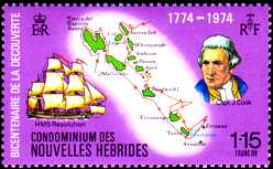
Then they went on to the Marquesas, Tahiti, Tonga, the New Hebrides and New Kaledonia.
|
|
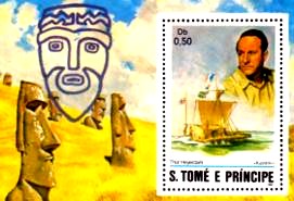
On a side note: On Easter, 1772 the Dutch seaman Roggeveen discovered an island which he named
after the historic date - Easter Island. He reported massive figures and statues of stone. Cook
took the chance to confirm the story. These monstrous monoliths from a time unknown are a subject
of speculations up to today. They probably originated from a culture native to America, which
travelled the Pacific to Polynesia. The Norwegian Thor Heyerdahl proved the potency of this
theory with a voyage on his raft 'Kon-Tiki' in 1947 (souvenir sheet to the right).
|
|
| |
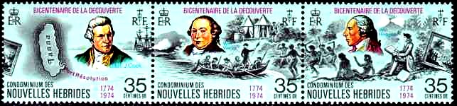
This is a typical landing scene. To the left you can see Cook with his ship and a chart
of the island Tanna, which belongs to the New Hebrides. In the middle the boat reaches the beach.
Cook standing in the bow with a palm branch as a symbol of friendship, because some natives
were using wild, menacing gestures and threatened with their spears. To the right the ship
painter, who documented the scene with a picture, including the waving native girls. In the center
the astronomer William Wales, to the right the painter William Hodges.
|
|
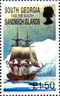
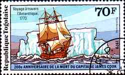
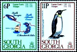
On their homebound voyage Cook sailed along the pack-ice border eastward from the Pacific
Ocean into the Atlantic Ocean. Along his yourney he discovered the snow covered islands of
South Georgia and the southern Sandwich Islands (stampto the left). To the right a penguin,
as witnessed and drawn by the ship's painter. Then Cook left the southern regions and set
course to the Cape of Good Hope.
|
|
|
|
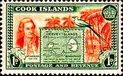
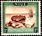
On these stamps you can see Cook with a chart of the atoll Hervey Island and the 'Resolution'
reaching the island Niue.
The second voyage lasted 3 years and 18 days. Cook and his ship have sailed for more than
300,000 kilometers, that is even more than seven earth circuits. He set new records for the highest
southerly latitudes achieved. Some of the discovered islands had been visited by explorers on
earlier expeditions, so Cook did not 'discover' them in the traditional definition. But his
contribution was to confirm, to reduce confusion, to replace vagueness and uncertainty with
exact accuracy. Cook had put an end to the search for the great southern continent. The results
of his first two voyages had effectively outlined the modern map of the South Pacific.
|
|
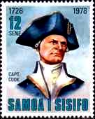
After returning from his second voyage, Cook found his fame had spread beyond his accustomed
naval circles. He was elected a Fellow of the Royal Society and awarded the Copley gold
medal. Cook was portrayed, dined with upper noble circles and became known as 'the First
Navigator in Europe' in the House of Lords.
He even got a new job ashore.....
But only one year later he returned to the Pacific.
|
|