|
|
Maritime Topics on Stamps :
History of the Compasses!
|
|
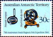
100 years ago, in March 1904, the German Hermann Anschuetz tested his first functional
gyrocompass during trial travels on the Kiel Foerde (fjord). For this reason 'Maritime Topics on Stamps'
reports something about the history of the compass.
The compass is a device for the determination of the directions. For this reason he is indispensable
to the navigation of ships (and airplanes). The term compass is derived from Italian 'compassare'
and means 'to stride araound', 'measuring'.
|
|
|
The first compasses were magnetic compasses. They use the magnetic field of the earth,
which exists between the magnetic north pole, in Canada, and the magnetic South Pole, in the Antarctic.
An iron or a magnetic needle is affected by the lines of force of this field and points constantly to
the magnetic north-south direction, see the stamp above. By this firm direction indication a ship could
be kept constant on a course, even if no country were in view! This made long voyages possible
over the oceans, see courses on the stamp to the left.
|
|
|
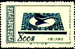
Two centuries before Chr. the magnet stone (magnetite) was well-known already to the Greek and the Chinese.
However the Chinese were probably first, who used this magnetite for the production of direction finder.
At the beginning there was a spoon cut from magnet stone. This very first compass served however
only for fortune-telling, see stamp to the right. The first written source about him dates around 80
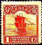
after Chr. Then in China the 'swimming fish' and the 'swimming needle' were invented and used as
direction finder on their junks, see stamp to the left. The Chinese were trading with Arab peoples and
they sailed even up to the east coast of Africa and to Australia.
The Chinese compass needles pointed to the south and were also called 'south finder'.
|
|
|
Trading Arabs took over the 'compass knowledge' from the Chinese. In the 12th century probably the compass
came into the Mediterranean with these Arabs. Consisted after a description of 1181 the first compasses in
Europe consist of a water bowl and a swimming straw, on which a needle lay, which had been magnetized
before by friction with a magnetite.
From that 13th century a Scandinavian compass with a wooden float in a bronze boiler was found.
1302 the Italian Flavio Gioia from Amalfi developed an useful ship compass. On the underside
of a glass plate he fastened soft iron staffs, on the top side the compass card was attached.
This disk turned on a needle, which was fastened in a box (bussole). It was a so-called dry
compass, which was in use on all sea-going ships in the 15th century, see illustrations on the stamps.
|
|
| |
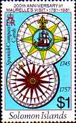
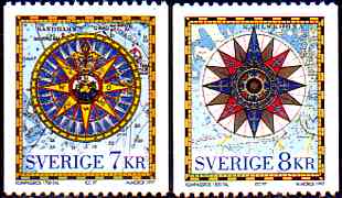
A compass card was divided into 32 'points'. Each point corresponded 11.25 degree. Today the compass
cards have a 360 degree graduation. On the Swedish stamps we see to the left of a compass card around 1700,
to the right of a card around 1500. On both the point graduation is recognizable.
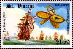
On the stamp to the right the multi-function navigational instrument of Sir Francis Drake is to be seen.
It served for the angular measurement, had port and tidal tables, was sundial, had a compass
(on the top right), a perpetual calendar and was a 'Nocturno', to adjust at night the polar star.
|
|
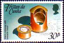
There ships incline to swing as well known and in heavy seas are pitching and rolling the swimming
compass (fluid compass) was invented. Into the compass box a mixture from alcohol and water was filled,
which absorbed the compass card of the ship movements. This happened however only around 1860.
The Italian Gerolamo Cardano, physician, philosopher and mathematician, developed 1537 his
'cardanic suspension'(gimbals), in order to hold the compass stably against the ships movements.
It concerns of three concentric rings, in which the compass hangs always perpendicularly. On the stamp
to the right a swimming compass and its binnacle are shown, in which one can recognize a cardanic ring.
|
|
| |
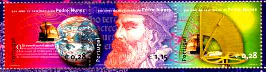
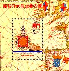
500 years before the Portuguese Pedro Nunes, which is shown on these souvenir sheet, was concerned
with the longitude regulation. In this process he recognized the problem with the 'variation'.
A compass card always points to the magnetic north pole. That lies not with the true north pole
in Canada and changes also his position. The variation (declination) is now the angle between
geographical and magnetic north pole. It is everywhere different and its value (with the changes)
is registered in the sea charts. It must be considered for the course computation.
|
| |
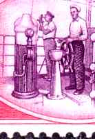
Besides this declination the so-called deviation must be considered too. Thus one calls
the deviations of the compass card, which are caused by the metal parts of the ship. On the other
hand a binnacle of wood was created, to whose both sides two iron balls were attached, see illustration
on the letter. Inside of the binnacle further horizontal and vertical soft
iron bars were attached. Then the ship 'was compensated', i.e. the ship drove a circle and
focused firm landmarks. The deviation of the compass by the ship iron could be determined and be kept
as small as possible with exact placing of these balls and soft iron bars. The remainder deviations
were noted in a deviation table and considered during the course computation
|
|
| |
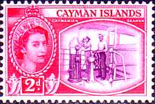
On this beautiful stamp we see a sailor at the steering gear and a ship officer with a sextant.
In front of the sailor the binnacle with its two balls is recognizable. In the semicircular
protection hood is a sight, so that the sailor can steer after the compass announcement.
|
|
| |
With a bearing compass one can focus visible landmarks to determine the ship position. Also the Vikings
used bearing plates (stamp to the left), with which however the sun shade was measured. See for
this the Navigation page.
.
The bearing compaas has a bearing circle (on the stamp to the right, left) with which one
the object was pinpointed. So the direction could be read off from the compass card. From
this a base line is computed and drawed into the sea chart. On this line the ship is located.
|
|
| |
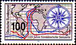
On many old sea charts we find multicolored compass cards and a network of lines, which meet all at
firm points, stamp to the right. These maps appeared from that 12th century and were called
'Portulane'. It is not proven until today, which function belonged to these lines, because they are no
degrees of latitude and longitude. They are surely meant as navigation aid and also as map decoration.
|
|
| |
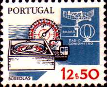
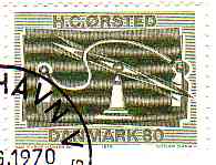
1820 the Dane HC-Mr. Řrsted observed the diverson of a magnetic needle by the electric current and
thereby he had discovered the electromagnetism, stamp to the left. In 1852 the Frenchman Foucault,
admits through his 'Foucault pendulum', brought the idea of the gyroscope compass on the way.
The axle of a rotating gyroscope is steered by the earth rotation in the north direction,
it points to the true north!
This gyroscope law is used with the gyroscope compass, which is independent of the magnetic field of the
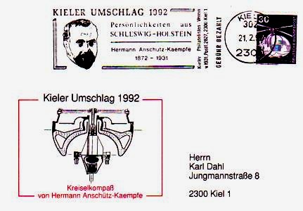
earth. The German Hermann Anschuetz-Kaempfe built the first functioning gyroscope compass. In it a
gyroscope rotated with 20.000 revolutions per minuted, see the card to the right.
|
| |
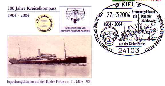
In 1904, 100 years ago, H. Anschuetz-Kaempfe accomplished the first sea-tests of his gyroscope
compass on the salon steamer 'Schleswig' in the fjord of Kiel. The tests were so successful so he
announced a patent in the same year on it. Improvements with a three-gyroscope and the
today usual two-gyroscope system followed. This compass stands in a protected interior of the ship and
is called master compass. On the bridge at the steering stand, in the radio direction finder, in the
radar and in the bridge cams the repeater compasses are installed, which get their announcement of the
master compass. By the speed of the ship a travel error can result with a gyroscope compass, which is
however negligibly small.
|
The rotation of the gyroscope compass is produced with electric current. Because of this current
dependence many ships have still another magnetic compass, usually above the bridge on the bearing deck.
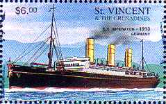
In 1913 on the HAPAG new building 'Imperator' an Anschuetz three-gyroscope compass were installed, stamp
to the right.
In 1920 Anschuetz developed also the first self steering system for shipping!
|
|
|