|
Maritime Topics On Stamps :
'Stormy Seas'!
|
|
Air is flowing from areas of high pressure to areas of low pressure.
The force of moving air is called wind. It originates in regions with different air
pressure or a gradient of temperature. Wind direction is determined by the positions
of the low pressure areas and the rotation of the earth. Wind velocity is measured on a scale
developed by the British admiral Beaufort. The scope ranges from zero (calm) over 8 (storm) to 12
(hurricane). In a storm the wind speed will reach 45 mph or more.
|
|
|
We have a complete planetary wind system on earth, with zones of constant winds, the famous Trade
Winds and areas where cyclones are very common. We know tropical cyclones like
hurricanes and taifuns as well as tornadoes and blizzards. There are the periodically
reappearing monsoons and local jet effects and fall-winds like Bora and Mistral. Then there are
the Doldrums with absolutely no winds at all.
Everyone living at the coast knows the daily change between the wind coming from the sea during
the day and the landfall-wind during the night.
The wind moves the sea to create waves. The motion of the sea is measured on a scale from zero to
nine. Force nine represents a wave height of 7 or more meters.
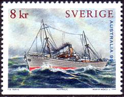
These stamps demonstrate the height of waves.
|
|
Storms can easily tear sails apart and break masts. Winds and waves are able
to haul over ships to one side, often causing the cargo to slide. This results in the ships
listing even further and being left at the mercy of the roaring sea (, see this stamp).
The cargo tied to the upper
deck can be washed into the sea, superstructure and hatches severely damaged and anchor chains
torn. It is possible to spring a leak and big ore carriers are subject to simply breaking apart.
Seas running over the decks represent grave danger for the life of seamen and passengers.
They could be washed over board or smashed against the superstructure. A strong storm can
cause a ship to sink.
|
|
|
| |
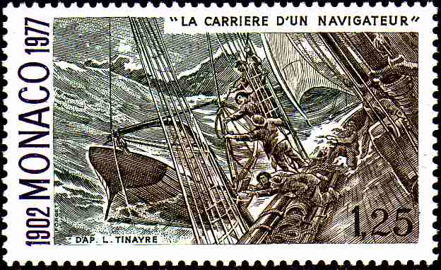
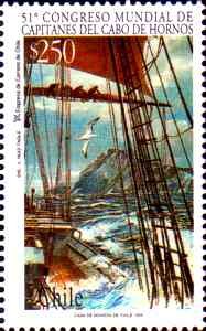
On sailing-vessels you have to reef or salve the sails early to prevent such risks and dangers.
The left stamp shows seamen salving their sails while a sea is washing upon the deck.
Normally the topsails are the first to be salved, followed by the big main sails. The sails in the
middle remained in place to keep the ship manoeuverable (Represented on the right
stamp.). On smaller vessels a drifting anchor was used or the vessel was left to drift crossways
to the sea. There are many methods to reduce the force of the waves. Sometimes long ropes were
brought out or oil was poored into the water to calm the sea.
|
|
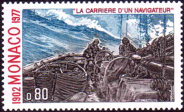
Today great passenger ships and cargo freighters are build to easily endure average storms.
Nevertheless good seamenship is mandatory. All moveable goods must be fastened by rope and
suspended with stow-wood. If the storm is getting too strong the vessel must be heaved to the sea.
There are different methods of 'heaving'. You can see one of them on the left stamp. The ship
is going with reduced speed straight against the wind, i. e. it directly takes on the waves with
the bow so the swell can't cause any heavy damage.
|
|
|
But the best precaution against storms is to plan your voyage through areas with low storm
frequency.
Weather stations all around the world publish recommendations on a daily basis. There are monthly
climate charts with average storm forces, frequency, directions and routes.
If you are studying the weather charts day by day, you can try to avoid upcoming storms.
If you aren't fast enough fleeing a tropical cyclone there is always a chance to reach a safe
'quadrant' of the storm with moderate winds.
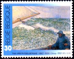
During a strong storm the sea is whitened by the foam. This is shown on the left stamp.
On the right stamp we can see a steamer fighting it's way through a muddled running sea, i.e. the
swell and the waves caused by the winds are comming from different directions.
|
|
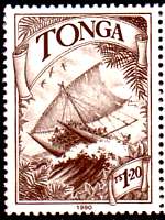
After the great sailing vessels and the general cargo ships we move on to two stamps with
sailing boats in stormy weather: First is a 'Maori double canoe', called 'Te Arawa'.
Another word for double canoe is 'Catamaran'. In the Indian language spoken by the Tamile minority
'Catamaran' means 'bundled wood'.
|
|
On this stamp we can see the white foam on the top of the waves again. The boat is sailing with
high speed in aft winds, i.e. the waves are running beyond the boat causing it to literally
'surf' the waves.
This situation demands extreme concentration from the man at the helm. The danger for capsizing
or breaking a mast is very high.
|
|
|
If cold polar air is moving over wet and warm air, the cold air can't maintain it's height and
crushes several miles down. This causes warm air to be catapulted up high. There the air is
condensed to large clouds which start turning round a round moved by the rotation of the earth.
Slowly a tube is forming reaching down to the surface. Thus a tornado is formed. On the outer rim
of the tube whind speeds reach upto 600 mph. The destruction potential of these forces is immense.
The diameter of a tornado may be only a few meters wide up to some hundreds of meters.
|
|
|
| |
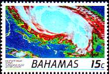
Tropical cyclones are formed by oceans with a water temperature of 27 degrees Celsius or higher.
The water condenses to wet, warm air masses which are rising from the surface and build clouds.
The air pressure at sea level drops dramatically and causes more wet air to be sucked into the
heights. A whirl is forming like in a tornado, but even larger. The diameter may reach up to 1500
miles, the wind speed up to 180 mph. In the centre of the whirl the air is sinking again to form a
cloudless 'eye'.
In the Atlantic ocean these tropical cyclones are called 'hurricanes', the Chinese say 'taifun',
the Indians call it 'cyclone' and the Australian people 'willy-willy'. Cyclones can only move
freely across the sea. When they reach the shore, they are stopped by the lack of the wet
warm air supply and the uneven surface. Most of the time, the wind speed decreases to a 'gentle breeze'.
Hurricane wind speed belongs to scope 12 at the Beaufort scale. Scope 12 is the end of this
scale. So a new scale, the Saffir-Simpson scale, was developed for tropical depressions.
This scale ranges from category 1 to category 5. Category 1 in the range
38 - 73 mph up to
category 5 with more than 155 mph.
|
|
Tropical cylones are given names to avoid confusion if there are too many of them at the
same time.
This was introduced during 1950. At first names of the international phonetic alphabet were used.
Since 1953 english women names, since 1979 changing male and female names. In the Atlantic area
the first hurricane of the year is given a name starting with the letter 'A', then followed by a name with the letter 'B' and so on.
|
|
|
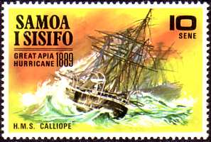
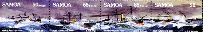
In 1889 a hurricane reached Apia on Samoa Island. The captain of the H.M.S Calliope wrote an
excact report about the difficult hours fighting the hurricane. The 'Calliope' had dropped
anchor (stamp valued 85sene) right behind the 'Vandalia' (stamp valued $2). During the hurricane
the 'Vandalia" was slowly driven back and collided with the British ship.
The 'Olga' (stamp valued 65sene) was lying very close to starboard and a vicious reef on the other
side.
Suddenly the 'Olga' turned loose too and rammed the 'Calliope'. In this situation, rammed by two
ships and with the reef nearby, the captain ordered full speed ahead, had the anchor cut and
successfully escaped this trap.
|
|
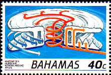
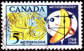
On this canadian stamp we can see a part of a weather chart with a low pressure area and the
accompanying front system. To the right there is an anemometer to measure wind speed, a wind
direction finder, an antenna and a balloon. Even today balloon starts happen every 6 hours at
meteorological stations. The balloon carries an instrument box which broadcasts data about air
pressure, temperature and height. During it's ascension it is monitored by radar to get information
about the direction and speed of the air currents. Our 'weather' happens in the troposphere, a zone
of 11 to 17 kilometers above ground must be closely observed and analyzed.
|
|
|
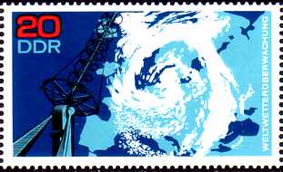
In the Zone of the Westerly Winds polar cold air runs into warm air. This crash
causes areas of low pressure or even cyclones to be formed. The boundaries of these
low pressure areas are called fronts. If warm air is shoving above cold air it is called a
warm front. We have a cold front if cold air presses against warm air. During the development of
a low system the faster cold front catches up with the warm front to form an occluded front.
This stamp shows a satellite picture of a great cyclone over Europe with an occluded front.
In the rear of such cyclones the wind can develop the force of strong storms or even hurricanes.
|
|
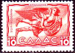
In earlier times wind and storms were often attributed to gods, because
nobody can actually see the wind despite it's immense strength. Greece and
Roman poets have written many stories about gods of the winds, i.e. Aeolus was the sovereign of the
winds. A 'Tower
of the Winds' with eight corners was build at the Akropolis in Athens. Eight human figures with
wings symbolized the eight main wind directions. We have a stamp set with these figures from Greece.
Here you can see Apeliotes representing the eastern winds. The other gods were Boreas (northern winds), Kaikias (northeast), Euros (southeast), Notos (south), Lips (southwest), Zephyros
(west) and Skiron (northwest).
|
|
Two examples of storms and religion:
|
|
|
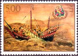
Many painters have crafted pictures of ships in heavy storms. Often these pictures included
religious symbols. On this stamp we can see Mother Maria with Jesus Christ watching the ship
in the upper right corner.
Despite the distraction the artist let the seamen do the right thing: Saving the sails!
|
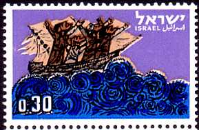
Three stamps from Israel fitting into the same theme: Jonas and the whale. Jonas was a prophet
in the Old Testament. When he wanted to leave God, his ship came into a storm and Jonas was
swallowed by a whale. Here you can see the stamp with the storm scene.
|
Have a look to our
Beaufort Windforce Scale!
Have a look to our State-of-the-Sea Scale!
|